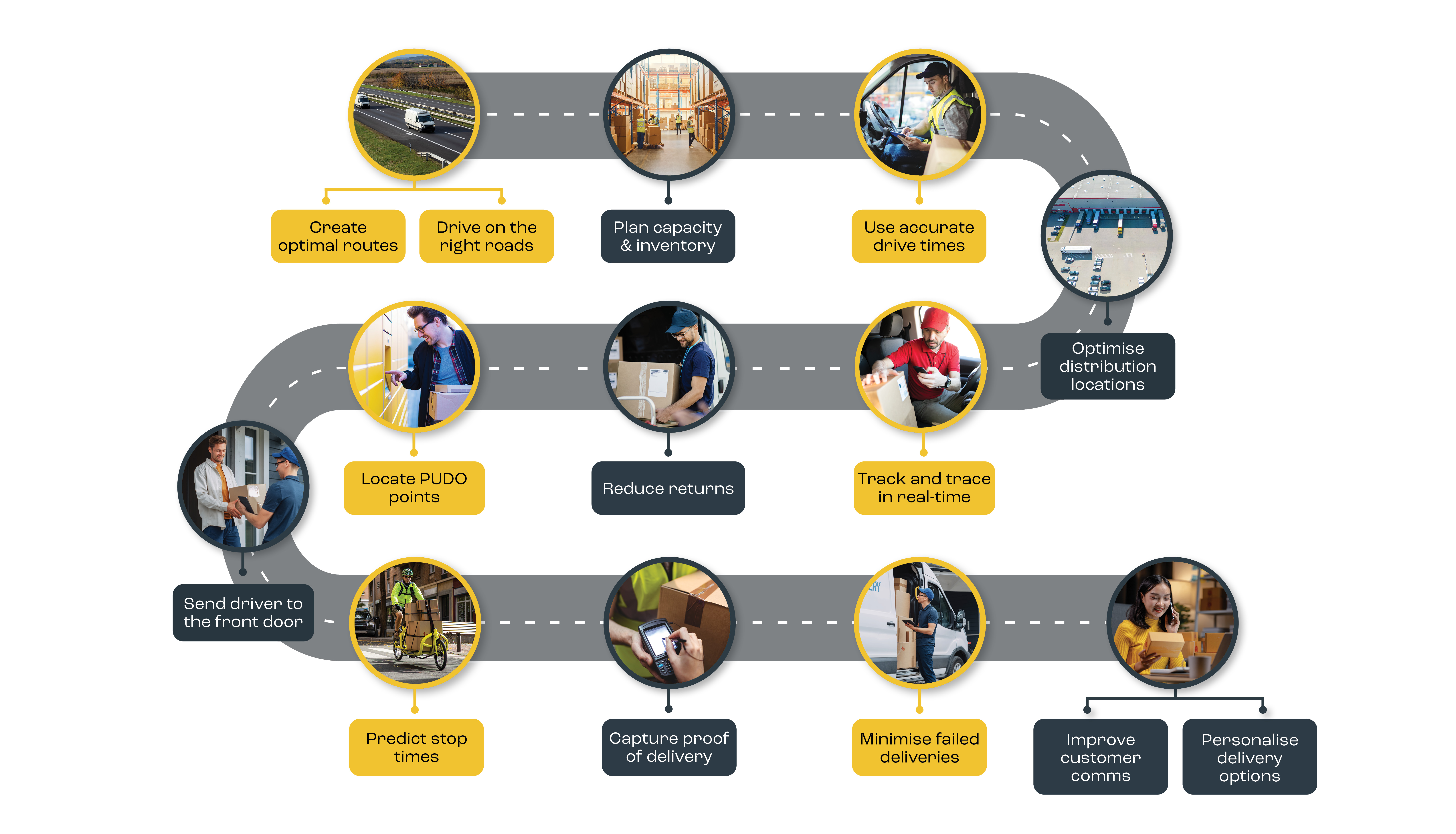
Search
  Optimisation and mapping to power your business
 

Drive time catchments (isochrones)

What are drive time isochrones used for?

Drive time catchments (also known as isochrones) show everywhere that can be reached within specified time from a specified point or points.

Typical applications include calculation of:

  • store catchments
  • depot areas
  • delivery pricing models
  • marketing campaign extents
  • Relocation fees
ASDA store picture illustrating user of MapMechanics drive time  isochrone solutions

Case Study: Drive times stand up to scrutiny of WALMART board>>>

Why choose MapMechanics drive time systems?

Many Isochrones at Once

Produces many isochrones around many points at once. So you could generate 5,10,15 minute isochrones around each of many store locations in a single batch.

Automatic Isochrone Naming

The system automatically names the isochrones according to a user specified field (e.g. store name) and the number of minutes. Very important when creating large batches of drive times.

Not Constrained by Nodes

When calculating how far can be reached in a given time, many systems "snap to the nearest node". The MapMechanics system is not limited in this way. It creates catchments half way across road links, if only half of the distance can be covered in the selected time.

Intuitive and Clear

The enhanced drive time system also has a host of features to improve clarity when using and presenting resultant isochrones.

There is optional smoothing, special features to clearly display multiple overlying drive times (for instance, at the coast a 20, 30 and 60 minute isochrones may all reach the sea and go no further), and translucent fills to overlay raster maps.

Range of Speeds

Standard speeds according to road class

Road classifications refined according to whether in urban or rural area

MapMechanics unique real speeds calculated from billions of ITIS GPS signals from real vehicles on the move.

There are separate data sets by time of day and for different vehicle types.

More about Speed Data>>>

Streets or Roads?

MapMechanics offers a choice of 100s of mapping options at street or road level. The shorter the time or distance you are interested in the more essential it is to choose a detailed street network to calculate meaningful results.

UK, Europe, World?

The comprehensive MapMechanics digital data catalogue includes road and street networks for regions, countries or continents.

Routable, Bridges Resolved...

Processed by MapMechanics using 20 years of experience to ensure your network is fully routable (full connectivity, bridge nodes resolved etc).

Meaningful journey times

Every day the time taken to make a standard journey (like our trip to the local shops) can vary depending on traffic, weather etc. However, we also know that on average it takes about 15 minutes or half an hour, for example. MapMechanics drive time can use the averages of billions of GPS signals from real vehicles to determine the most likely journey time.

Neal Stevenson of ASDA said

“The great thing about this system is that the road speeds are averaged over multiple journeys, so we can be confident that they’re realistic,”

“This is a huge advantage. By contrast, when we actually drive the routes, we’re subject to the vagaries of bad weather, road works, unduly heavy traffic and other local anomalies.”

Drive times are key

People decide whether to use facilities based on how good they are versus how awkward they are to get to. Similarly deliveries are only viable if they can be made in a timely and cost effective manner. So the key to drive time systems is to calculate as closely as possible the time it is likely to take.


Drive time systems

All drive time systems involve two essential components: software (the way in which the possible routes are calculated) and data (the roads or streets used and the speeds allocated to each part of the journey).

MapMechanics have 20 years experience in making the most of technological advances to help you maintain a competitive edge.